


介绍 Flowx: Weather Map Forecast
Visualize the forecast, for anywhere in the world, with the unique Flowx weather map and graphs. Move your finger across the screen to control the forecast animation over time. Select the data for your needs from 30+ data types and 18 forecast models, plus radar reflectivity and hurricane tracks. Use Flowx to plan around the weather, for aviation, fishing, sailing, surfing, cycling, hiking, photography, storm tracking or anyone interested in the weather.
The advantage of Flowx is the interactive forecast map, giving you the 'big picture' and enabling you to understand the weather. With Flowx, you have control of the forecast information: compare models and interpret what the data means for you, to best plan your activities.
Flowx was awarded Google Play Editors’ Choice: The 5 Best Weather Forecast Apps.
Flowx Features:
Data Types: 30+ data types including precipitation, cloud, wind, temperature, pressure, humidity, waves and more.
Data Sources - Free:
• NOAA GFS (FV3) - Global
• NOAA NWW3 - Global
• CMC GDPS - Global
• CMC GDWPS - Global
• NOAA HYSPLIT Smoke Data - Continental USA
• Storm/Hurricane Tracks (NOAA & CMC) - Global tropical storms
Data Sources - Pro:
• RainViewer Radar - 82 countries
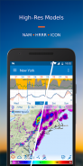
• NOAA NAM - Continental USA
• NOAA HRRR - Continental USA
• NOAA RTOFS Ocean Model - Global
• DWD ICON - Global
• DWD ICON-EU - Europe
• MeteoFrance ARPEGE - Europe
• MeteoFrance AROME - France
• European Consortium HIRLAM - Europe
• DWD COSMO-D2 - Germany
• CMC RDPS - Canada, USA (incl. Alaska), Greenland, Iceland
• CMC HRDPS - Canada
• KNMI HARMONIE 2.5km- Netherlands
• KNMI HARMONIE 5km - Europe/UK
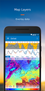
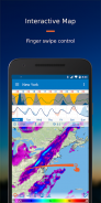
b>Map: use finger swiping to control the forecast animation over time. Choose multiple data layers to display on the map, for example precipitation and cloud layers with wind streamlines.
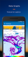
Graphs: view the week’s weather forecast data at a glance. Choose from a selection of graphs and use the 'compare function' to view all data sources at once.
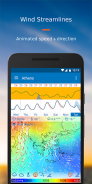
Wind Streamlines: animated streamlines indicate wind speed and direction.
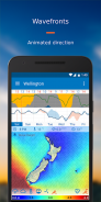
Wavefronts: animated wavefront lines indicate wave direction.
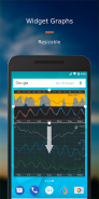
Widget: resize your widget to display multiple graphs.
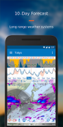
16-Day Forecast: with pro version you can view up to 16-days forecast.
3-day Hindcast: with pro version you can view up to 3-days historical hindcast & radar.
Graph Editor: with pro version you can customize your graphs by selecting data types.
Map Styles: with pro version you can choose from multiple map options.
Travel Mode: automatically updates the forecast for wherever you are in the world.
Offline Use: after updating the data, use the app offline to view the forecast without internet.
Permissions: minimal permissions required.
Pro Versions: choose the pro version option that best suits your needs, see in app for details.
Try Flowx Today: visualize the forecast and understand weather systems - it’s the smart way to plan around the weather.
* Flowx was formerly known as WeatherBomb.
Contact:
Join us at forum.flowx.io to ask questions and discuss ideas.
Follow us on social media:
Facebook: facebook.com/flowxapp
Twitter: twitter.com/flowxapp
YouTube: youtube.com/flowxapp
使用独特的Flowx气象图和图表直观地显示全球任何地方的天气预报。在屏幕上移动手指以控制随时间变化的预测动画。从30多种数据类型和18种预测模型中选择适合您的数据,再加上雷达反射率和飓风轨迹。使用Flowx计划天气情况,以便进行航空,钓鱼,航行,冲浪,骑自行车,远足,摄影,风暴追踪或任何对天气感兴趣的人。
Flowx的优势是交互式预报地图,可让您“纵览”,并让您了解天气。使用Flowx,您可以控制预测信息:比较模型并解释数据对您的意义,以最佳地计划您的活动。
Flowx被授予Google Play编辑器之选:5个最佳天气预报应用程序。
Flowx功能:
数据类型: 30多种数据类型,包括降水,云,风,温度,压力,湿度,波浪等。
数据源-免费:
•NOAA GFS(FV3)-全球
•NOAA NWW3-全球
•CMC GDPS-全球
•CMC GDWPS-全球
•NOAA HYSPLIT烟雾数据-美国大陆
•风暴/飓风轨道(NOAA和CMC)-全球热带风暴
数据源-专业版:
•RainViewer雷达-82个国家
•NOAA NAM-美国大陆
•NOAA HRRR-美国大陆
•NOAA RTOFS海洋模型-全球
•DWD ICON-全球
•DWD ICON-EU-欧洲
•MeteoFrance ARPEGE-欧洲
•MeteoFrance AROME-法国
•欧洲财团HIRLAM-欧洲
•DWD COSMO-D2-德国
•CMC RDPS-加拿大,美国(包括阿拉斯加),格陵兰,冰岛
•CMC HRDPS-加拿大
•KNMI HARMONIE 2.5公里-荷兰
•KNMI HARMONIE 5公里-欧洲/英国
b>地图:使用手指轻扫来控制随时间变化的动画。选择多个数据层以在地图上显示,例如具有风流线的降水层和云层。
图表:一目了然地查看一周的天气预报数据。从一系列图形中进行选择,然后使用“比较功能”一次查看所有数据源。
风力流线:动画流线指示风速和风向。
波前:动画波前线指示波的方向。
小部件:调整小部件的大小以显示多个图形。
16天预测:使用专业版,您最多可以查看16天预测。
3天的后播:带有专业版,您可以查看长达3天的历史后播和雷达。
图形编辑器:使用专业版,您可以通过选择数据类型来自定义图形。
地图样式:专业版,您可以从多个地图选项中进行选择。
旅行模式:自动更新世界各地的天气预报。
脱机使用:更新数据后,可以离线使用该应用以查看没有互联网的预测。
权限:所需的最低权限。
专业版:选择最适合您需求的专业版选项,有关详细信息,请参见应用程序。
立即试用Flowx:可视化天气预报并了解天气系统-这是围绕天气进行计划的明智方法。
* Flowx以前称为WeatherBomb。
联系:
通过 forum.flowx.io 加入我们,提出问题并讨论想法。
在社交媒体上关注我们:
脸书: facebook.com/flowxapp
Twitter: twitter.com/flowxapp
YouTube: youtube.com/flowxapp
Flowx: Weather Map Forecast - 版本3.412
(26-12-2023)

Flowx: Weather Map Forecast - APK信息
APK版本: 3.412程序包: com.enzuredigital.weatherbomb同类应用
您可能还会喜欢……


